Plate: direction of effect: road signs in Tashkent

Plate: direction of effect: road signs in Tashkent — 2 photos with addresses and landmarks

2 photos · all “Road signs”

Road signs “Plate: direction of effect” on the map

All 2 with a geotag. Click a point for the photo and description.

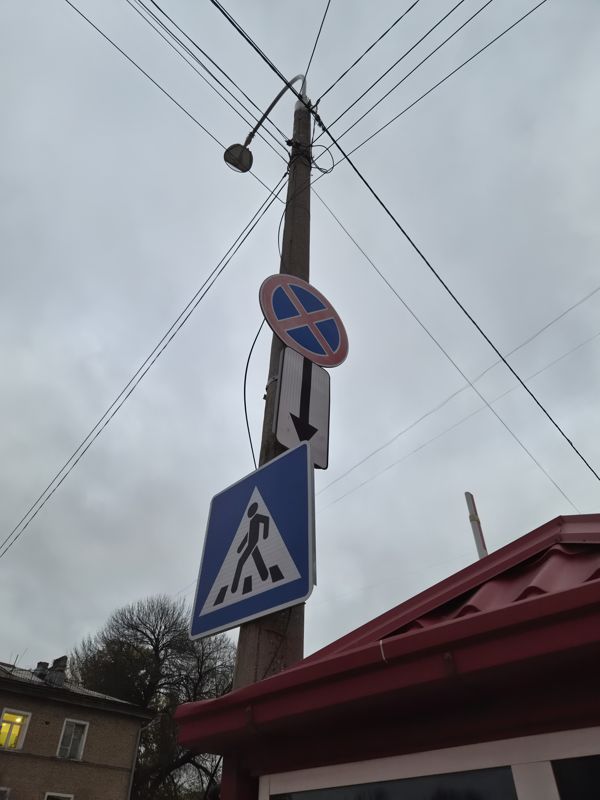
On a concrete lamp post, from bottom to top: a blue “Pedestrian crossing” sign, above it a plate with a downward arrow and a round sign with a red cross “No stopping”; a red kiosk roof nearby

On a concrete lamp post, from bottom to top: a blue “Pedestrian crossing” sign, above it a plate with a downward arrow and a round sign with a red cross “No stopping”; a red kiosk roof nearby

No stoppingPedestrian crossing (information sign)Plate: direction of effect
No stopping: Крепление: на бетонном столбе освещения · Состояние: красная кайма выцвела
Pedestrian crossing (information sign): Крепление: на бетонном столбе освещения
Plate: direction of effect: Надпись: стрелка вниз · Крепление: под знаком «Остановка запрещена» на том же столбе
41.329351, 69.32465741°19'45.7"N 69°19'28.8"E
on the map: OSM · Esri · CARTO · Google Maps · Yandex Maps · altitude 429 m
2026-11-11 17:10 · photo page
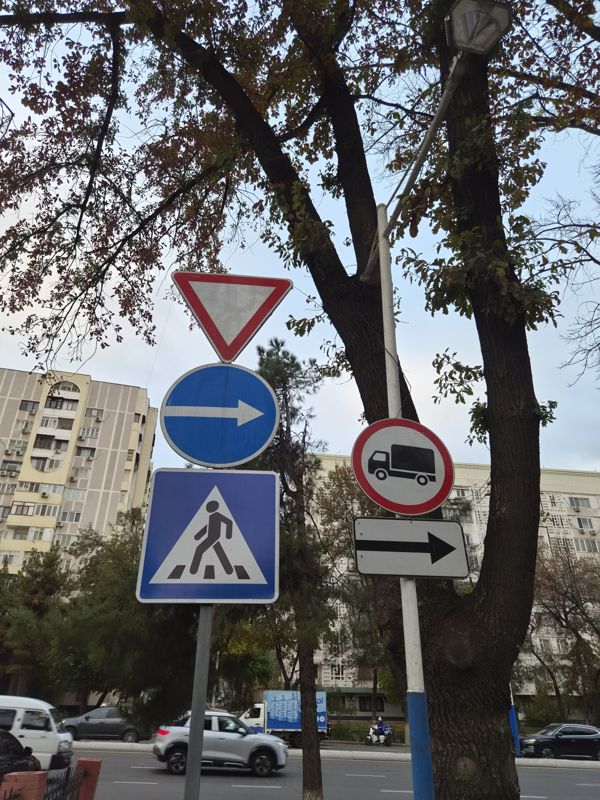
Two posts under a tree: on the left, from top to bottom, “Give way”, “Proceed to the right” and a blue “Pedestrian crossing”; on the right, “No trucks” with a plate with an arrow pointing right; along an avenue

Two posts under a tree: on the left, from top to bottom, “Give way”, “Proceed to the right” and a blue “Pedestrian crossing”; on the right, “No trucks” with a plate with an arrow pointing right; along an avenue

No heavy goods vehiclesPedestrian crossing (information sign)Give wayTurn rightPlate: direction of effect
No heavy goods vehicles: Крепление: на сине-белой стойке
Pedestrian crossing (information sign): Mounting: on its own post
Give way: Mounting: on its own post
Turn right: Mounting: on its own post
Plate: direction of effect: Надпись: стрелка вправо · Крепление: под знаком на той же стойке
41.320318, 69.30156941°19'13.1"N 69°18'05.6"E
on the map: OSM · Esri · CARTO · Google Maps · Yandex Maps · altitude 421 m
2026-11-11 16:31 · photo page
↑